The Agricultural Weather Study
Minnesota CliMAT (Climate Mapping and Analysis Tool) is now live!
Project Summary
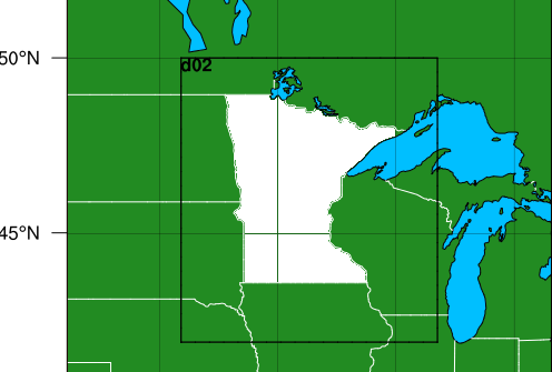
Assumptions about climate are embedded in how we design and manage many of the systems and resources we rely on every day from how we design our infrastructure to manage stormwater and when to plant our crops to how we design railways and bridges and how we assess risk of infectious diseases. But the climate of the past is no longer the best predictor of future climate. To better understand future climate risks, we need future climate models. To address this need, the State Legislature of Minnesota supported MCAP to generate future climate projection data and associated resources to support the use and application of these data.
Differentiating the impacts of climate change at a fine spatial scale is particularly important in Minnesota, where we see large south-to-north gradients in warming, have long-duration snow cover, large and small lakes and other complexity in our climate. In order to provide reasonable climate projections over Minnesota on the regional scale, we need information that captures these changes.

Through this project, MCAP is:
- Generating future climate data at a ~3-mile resolution through the year 2100 using the most recent global climate models (CMIP6). Using dynamical downscaling techniques, we will model variables such as precipitation, temperature, soil and lake temperature, etc.
- Developing an interactive visualization of these climate model projections, in partnership with U-Spatial, to help Minnesotans access and use the data in their climate adaptation planning and decision-making
- Developing Extension programming, training, and other communication resources on effective climate risk management for individuals and practitioners from across different sectors including agriculture, forestry, natural resources, and the built environment.
Results from this effort will be captured and shared through a publicly available report. MCAP and its partners will use results to develop the online data tool as well as training and support materials. In addition, both the process and results of this effort will be of interest to other states or regions developing software-based tools for the provision of climate data.
Project Highlights
Preliminary results from a recent statewide survey conducted by MCAP and the climate data workgroup under the State’s Resiliency and Adaptation Action Team, indicates a broad, cross-sectoral demand for these data and increased support for using these data in practice. Over 80% of respondents felt that fine scale climate projection data were very to somewhat important for carrying out their climate-related work. Anticipated applications of these data spans everything from agricultural decision-making and water resources management to infrastructure design and community engagement. In addition to high demand from State agency staff, researchers, non-profits and the private sector all have needs and applications for this critical climate information.
In addition, Dr. Stefan Liess showed in a recently published study that Minnesota could see up to 60 fewer days per year with snow on the ground by 2100. Hear more about the study from Dr. Liess's interview on Minnesota Public Radio. Continue reading about the Liess, et al. study.
The project team has developed a Climate Modeling Introductory Primer for Practitioners to provide an introductory overview to climate models and their function for those who would like to understand or are interested in using climate model output.
Read about our project progress in our Year 1 report.
Project Team

Heidi Roop
Director

Suzi Clark
PostDoctoral Associate

Tracy Twine
Assistant Professor
University of Minnesota

Stefan Liess
Climate Researcher
University of Minnesota

Peter Neff
Assistant Research Professor
University of Minnesota

Peter Snyder
Associate Professor
University of Minnesota

Nathan Meyer
Associate Director

Jamie Mosel
Climate Resilience Extension Educator

Alejandro Fernandez
Ph.D. Student

Ryan Noe
Geospatial Developer
U-Spatial

Pete Wiringa
Computing Geospatial Analyst
U-Spatial

Amanda Farris
Senior Program Manager

Jack Gorman
MCAP Intern
Project Support
Minnesota Department of Commerce
Minnesota Corn Growers Association
References
Dahms, G.H., 2021: S.F. No. 19 – Commerce Energy Omnibus Budget Bill (Articles 3 – 8). URL.
Clark, S., et al., 2021: Climate Change Data For Minnesota: Understanding needs, uses and opportunities of climate information to help accelerate climate resilience efforts across the State. A report prepared for the State of Minnesota by the Dynamically Downscaled Climate Information Workgroup, the Minnesota Climate Adaptation Partnership and University of Minnesota Extension.
Cook, J., et al., 2013: Quantifying the consensus on anthropogenic global warming in the scientific literature. Environmental Research Letters. 8 024024. doi:10.1088/1748-9326/8/2/024024.
Liess, S., Twine, T. E., Snyder, P. K., Hutchison, W. D., Konar-Steenberg, G., Keeler, B. L., & Brauman, K. A. (2022). High-resolution Climate Projections over Minnesota for the 21st Century. Earth and Space Science, 9, e2021EA001893. https://doi.org/10.1029/2021EA001893
Notaro, M., D. Lorenz, C. Hoving, and M. Schummer, 2014: Twenty-First-Century Projections of Snowfall and Winter Severity across Central-Eastern North America. Journal of Climate, 27, 6526–6550. doi:https://doi.org/10.1175/JCLI-D-13-00520.1
Roop, H., T. Twine, and A. Farris, 2022: Agricultural Weather Study Interim Report to the Minnesota Department of Commerce.